HYDROLOGIC INVESTIGATION
ADWR AND USGS SEVEN YEAR STUDY
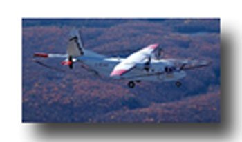
Airborne Geophysical Survey
A fixed-winged aircraft was used by ADWR and USGS to conduct an airborne electromagnetic survey in the area during March and April, 2006.
Results of the survey defined the extent of silt, clay, sand and gravel. This information will help us to understand the potential for water availability in the area.
OBJECTIVES:
- Access current state of knowledge, existing data collection networks, and determine needs for improvement.
- Define the shape, size and parameters of the groundwater system.
- Quantify the water budget including total water in storage, location and quantity of recharge, and evaluate historical changes.
- Evaluate groundwater quality in selected areas.
- Construct a predictive numerical model of the groundwater system that can be used by planners and water managers.
- Establish an on-going monitoring network.
- Inform residents of the Middle San Pedro area about the hydrologic conditions.
PROPOSED TIME LINE FOR STUDY
2005 – Begin study in October
2005-2009 – Data collection
2009 – Begin Ground Water Model
2010 – Publish report describing study results
2012 – Complete model and publish model report
AREAS RECEIVING SPECIAL ATTENTION
- The Narrows
- Kartchner Caverns
- Benson
- Proposed new residential development areas
- Known ares of water contamination